| Cemetery Name |
Directions |
| Abbot Cemetery |
Located in NE 1/4 S28-T60N-R18W. From intersection of Hwy 11 and Hwy HH, about 2 1/2 miles west of New Boston, go north on Hwy HH about 3 miles to a dirt lane going west. Go west on this lane about 1/4 mile to the west end of a bend in the lane. Walk south on the ridge about 250 yards; cemetery is on the west side of the ridge and is marked by an iron fence around the single remaining grave. |
| Anderson Cemetery |
Located in NW 1/4 S29-T58N-R18W. From the intersection of Hwy 36 and Hwy U, north of Marceline, go north on Hwy U about 4 miles, then go west on a gravel road about 1/4 mile. The cemetery is about 50 yards west of a two-story home and about 10-15 yards south of the road. |
| Baker, Andrew Cemetery |
Located in NW 1/4 S7-T59N-R18W. From the intersection of Hwy 11 and Hwy PP north of Brookfield, go south on a gravel road about 600 yards to the ridge top. Here a private dirt lane leads to the cemetery. The dirt lane goes west for about 1/4 mile then turns south for about 1/4 mile to a fence line. Thru a gate, the lane goes south on a ridge, but the cemetery is on the next ridge to the west and about 50 yards south of an old house (about 1/4 mile south of the fence gate). |
| Baker, Bolin Cemetery |
Located in SW 1/4 S17-T59N-R18W. From St. Catharine, go north on Hwy 11 about 8 1/2 miles to a gravel road going east. Go east for about 1 3/4 miles, then turn south and go about 1/4 mile. At an intersection bear to the right (southwest). Continue southwest for about 1/8 mile; cemetery is west of the road about 300 yards on a ridge. |
| Baker-Findley Cemetery |
Located in NE 1/4 S20-T60N-R18W. From intersection of Hwy 11 and Hwy PP, go north on Hwy PP to end (about 4 1/2 miles). Turn left (west) on a gravel road and go about 1/4 mile. Cemetery is south of the road 75-100 yards and is south of a tin barn and tin grain bin. |
| Baker, G. V. Cemetery |
Located in SE 1/4 S17-T60N-R21W. From Meadville, go north on Hwy 139 about 16 miles to Hwy MM; then go east on MM about 1 1/2 miles. Turn south on a gravel road and go 1 mile, then turn left (east). Go east 1 mile then turn left (north). Go north about 0.3 mile; cemetery is west of the road about 125 yards. |
| Baker, George W. Cemetery |
Located in SW 1/4 S11-T60N-R19W. From intersection of Hwy O and Hwy OO at North Salem, go south on Hwy OO 0.2 mile to a private drive leading west from highway toward an old house and barn. This lane is about 100 yards north of the church; follow lane west to just east of the old house then go south and southwest along the ridge. Stay on the west side of the barn then follow ridge to where ridge drops off sharply; an old pond will be to the left and below the cemetery. |
| Baker, Jerome Cemetery |
Located in NW 1/4 S8-T60N-R18W. From intersection of Hwy 11 and Hwy PP, west of New Boston, go north on Hwy PP to end of state maintenance then turn right (east). Follow gravel road east then north about 1 1/2 miles to an intersection of gravel roads. In the northwest corner of this intersection is a gate to a farm field. Cemetery is accessible only by 4-wheel drive vehicle and then only in dry weather. |
| Bailey Cemetery |
Located in SW 1/4 S22-T59N-R19W. From intersection of Hwy C and Hwy V, go south on Hwy V about 3 miles then turn left (east) on a gravel road where Hwy V curves to the south. Go east about 1/4 mile where a gravel road turns north. Continue east through the field; cemetery was somewhere over crest of ridge, probably north of the field lane. |
| Banning Cemetery |
Located in NE 1/4 S31-T58N-R19W. From Brookfield, go north on Hwy M about 1/2 mile, then turn right (east) on a gravel road. Go east 1 mile to an intersection with another gravel road going north; cemetery is about 25 yards south of the road in a clump of trees. |
| Baugher Cemetery* |
Located in SE 1/4 S32-T59N-R18W. From the intersection of Hwy 36 and Hwy U, north of Marceline, go north on Hwy U about 7 miles. Here the road bends to the east; go past the bend about 3/4 mile (the road again bends east). At this second bend, a gravel drive goes north. Follow this land about 0.7 mile, going north at the split in the road; cemetery is on the left (west) side of the road about 100-150 yards north of the split. Follow road to north end of Switzer Chapel Cemetery, then on foot, follow right hand branch of trail. At bottom of hill, the trail is going east; continue east along the fence to where a fence line goes north; cemetery is about 300 yards north of this point on east side of fence. |
| Bear Branch Cemetery |
Located in NW 1/4 S16-T59N-R19W. From intersection of Hwy C and Hwy V, go south on Hwy V about 1 mile then turn right (west) on a gravel road. Follow gravel road about 1/4 mile, then turn left (south) for 1/4 mile; church and cemetery are on east side of road. |
| Becket Cemetery |
Located in NW 1/4 S16-T58N-R20W. From Linneus, go east on Hwy P about 2 miles to where road curves sharply to the north. Take a gravel road east, then south. Go south about 2.3 miles; cemetery is east of road about 125 yards. |
| Bethel Cemetery(East Strawberry)* |
Located in SE 1/4 S32-T59N-R21W. From intersection of Hwy 139 and Hwy B north of Meadville, go east on Hwy B 2 miles to a gravel road going north. Go north on the gravel road about 50 yards; cemetery is on west side of the road. |
| Botts Cemetery* |
Located in SW 1/4 S18-T58N-R21W. From Meadville, go north on Hwy 139 about 3 miles; cemetery is on east of road just north of a gravel road going east. |
| Bowyer Cemetery |
Located in SE 1/4 S2-T58N-R21W. From Linneus, go south on Hwy 5 about 1/4 mile to first gravel road west. Go west about 1/2 mile, then turn north at a four-way intersection. Follow road north then northwest about 1 mile to end of road. Cemetery is about 150 yards south of a driveway in a group of trees. |
| Brown Cemetery |
Located in SW 1/4 S18-T59N-R20W. From Purdin, go south on Hwy 5 to first gravel road west. Go west on gravel road about 3/4 mile to intersection; cemetery is southeast about 100-150 yards east and 50 yards south of road. |
| Brownlee Cemetery |
Located in NW 1/4 S22-T58N-R18W. This cemetery is listed in the 1883 Linn County History, page 647, but no trace of it has been found. |
| Bull Cemetery |
Located in SW 1/4 S13-T60N-R19W. From intersection of Hwy 11 and Hwy C, go west on Hwy C about 1/4 mile, then go north on Hwy CC. Continue north on Hwy CC about 4 3/4 miles; cemetery is less than 1/4 mile north of intersection with the 3rd gravel road going east. Cemetery is at a much lower elevation than road and cannot be easily seen approaching from the south. It is now marked by 3 large cedar trees, and is about 150 yards from road. |
| Calhoun Cemetery* |
Located in SW 1/4 S11-T60N-R21W. From Browning, go west on Hwy MM about 3 1/2 miles. Cemetery is about 220 yards south of road and is best reached by a private drive to the house, then cemetery is about 100 yards east. |
| Calvary Baptist (Garner) Cemetery |
Also known as Garner Cemetery
Located in SW 1/4 S36-T60N-R19W. From intersection of Hwy 11 and Hwy C, go west on Hwy C about 1/4 mile, then go north on Hwy CC. Continue north on Hwy CC just over 1 mile; cemetery & church are on west side of road. |
| Cash Cemetery* |
Located in NW 1/4 S15-T57N-R18W. From intersection of Hwy 36 and Hwy 129, go west on Hwy 36 about 1/2 mile, then turn south on a gravel road and go about 0.3 mile; cemetery is west of road about 550-600 yards. |
| Cassity Cemetery |
Located in SE 1/4 S30-T59N-R20W. From Linneus, go north on Hwy 5 about 1 1/2 miles to a gravel road east. Go east on this road bending south for about 1/4 mile to a private drive next to a farm home. Follow drive east past house and barn about 1/4 mile to cemetery; cemetery is on right side of lane just past a pond. |
| Cherry Cemetery |
Located in SE 1/4 S23-T59N-R21W. From Linneus, go north on Hwy 5 about 1 12/ miles to first gravel road west. Go west about 1 1/2 miles to where the road turns north, then go north about 3/4 mile. Cemetery is west of the road about 75 yards. |
| Couch Cemetery |
Located in SW 1/4 S36-T59N-R21W. From intersection of Hwy 5, Hwy B and Hwy P in Linneus, go north on Hwy 5 four blocks then turn west. Follow this street west about 1 1/4 miles to entrance of Linneus City Lake. Turn into Lake entrance and drive to spillway. At spillway, walk north about 300 yards up ridge; cemetery is on east side of ridge in a clump of trees. |
| Coulson Cemetery |
Located in NW 1/4 S15-T58N-R18W. This cemetery is listed in the 1883 Linn County History, page 647. It no longer exists and stones were reportedly moved to the Wyandotte Cemetery by George Coulson. |
| County Farm Cemetery |
From Linneus, go west on Hwy B about 0.9 mile; cemetery was on north side of road, north of a red shet and near the timber line on the north slope of a steep hill. No stones are presently found. |
| Crail & Moore Cemetery |
Located in SE 1/4 S1-T59N-R18W. From New Boston, go south on Hwy 129 a short distance past the church in the southeast corner of New Boston; cemetery is east of the road on a ridge about 125 yards from highway. The single burial here was reportedly moved to the Helton Cemetery in Macon County. |
| Dry Ridge Cemetery* |
Also known as Bennett and Mundell.
Located in SW 1/4 S13-T60N-R21W. From Browning, go west on Hwy MM from Hwy 5 about 2 1/4 miles to jct. Hwy Z. Turn south on gravel road (Z goes north) about 1 1/4 miles to cemetery on east side of road. |
| Dryden Cemetery* |
Located in SW 1/4 S19-T59N-R20W. From Linneus, go north on Hwy 5 about 1 1/2 miles to second gravel road west. Go west then north on this gravel road about 9/10 mile; cemetery is on right (east) side of road. |
| Elmwood Cemetery (IOOF)* |
Located in SE 1/4 S20-T57N-R18W. From Marceline, go north on Hwy 5 to city limit, then east on a gravel road 1/2 mile. Turn north on another gravel road approximately 1/8 mile beyond railroad tracks. Cemetery is on left side of the road. |
| Enterprise Cemetery |
Located in NW 1/4 S13-T60N-R20W. From intersection of Hwy O and Hwy KK (about 3 miles east of Browning), go east on Hwy O about 1 1/4 miles, then turn right (south) on a gravel road; go south about 0.8 mile to first gravel lane; turn right (west). Follow this road 0.4 mile to cemetery on left. |
| Ford Cemetery |
Located in NW 1/4 of NW 1/4 S1-T59N-R22W. The site stands on the east bank of Smokey Creek in the timber. The two stones have probably been moved from their original location. |
| Fore Cemetery |
Located in NE 1/4 S32-T59N-R20W. From Linneus, go east on Hwy P about 1 1/2 miles to first gravel road north. Go north 1 mile, then go west about 1/8 mile; cemetery is about 250 yards south of road. |
| Forman Cemetery |
Located in NW 1/4 S32-T57N-R21W. From intersection of Hwy 36 and Hwy W, south of Meadville, go south on Hwy W about 4 1/2 miles and where the highway curves west, continue south but quickly turn left (east) on a gravel road. Go east about 1 1/2 miles to a parking area at end of road. Cemetery is about 100 yards north, marked by some large trees. |
| Fosher Cemetery |
Located in SE 1/4 S24-T59N-R20W. From intersection of Hwy M and Hwy C north of Brookfield, go south on Hwy M about 3 miles to a gravel road going west. Go west about 1/4 mile; cemetery is on the right (north) side of the road. |
| Gilmer Cemetery |
Located in SE 1/4 S31-T60N-R20W. From Purdin, go north on Hwy 5 from junction with Hwy C about 1/2 mile, then right on a gravel road. Follow road, keeping left past an intersection and then a private drive to a bridge over Lowes Branch. Go past the bridge 300-350 yards; the bottom ground on the left should start sharply uphill. Follow this contour west about 1/4 mile to the second ridge. Cemetery is up on the ridge just north of a pipeline. |
| Gooch Cemetery* |
Located in SE 1/4 S29-T60N-R20W. From Purdin, go north on Hwy 5 to 4th road going east. Go east 1/4 mile, then south 1/4 mile, then east about 1 1/4 miles. Turn south and go about 1/4 mile; road leads right to cemetery. |
| Grantsville Cemetery* |
Located in SW 1/4 S11-T59N-R20W. From intersection of Hwy C and Hwy KK east of Purdin, go south on a gravel road about 1 mile, then turn left (east). Go east about 1/2 mile; cemetery is on left (north) side of road about 100 yards. |
Grove Hill Cemetery
Also known as Guyer Baptist Cemetery |
Located in NW 1/4 S9-T59N-R19W. From intersection of Hwy C and Hwy V, go south on Hwy V about 1/2 mile; cemetery is on west side of road. |
| Hayes Cemetery |
Located in NW 1/4 S31-T60N-R21W. From Meadville, go north on Hwy 139 about 13 miles to Hwy DD; turn right (east) on DD and go 1/2 mile. Cemetery is about 100 yards south of road on west side of fence. |
| Haseville Cemetery |
Located in NW 1/4 S13-T60N-R22W. From Meadville, go north about 16 miles on Hwy 139 to Hwy E; then go west on Hwy E about 1/4 mile; cemetery is on the left (south) side of the road east of the church. |
| Hooker Cemetery* |
Located in NE 1/4 S16-T60N-R21W. From Browning, go west on Hwy MM about 4 1/2 miles then turn south on a gravel road. Go south about 3/4 mile; cemetery is about 50 yards west of the road just before a ´T´ intersection. |
| Jenkins Cemetery* |
Located in SE corner S17-T60N-R20W. Go east on Hwy O from Browning about 3/4 mile to a gravel road south. Go south about 1 1/2 miles to cemetery on right. Or, go south on Hwy 5 about 1 1/2 miles then east on a gravel road about one mile plus; cemetery on left at a ´T´ intersection. |
| Jones Cemetery |
Located in SW 1/4 S10-T59N-R20W. From Purdin, go east on Hwy C to Hwy KK, then south on a gravel road about 1 mile, then turn right (west). Go west about 3/4 mile to a farm house on north side of road. The cemetery was probably about 3/8 mile north of the house; stones were found in a pile of old fence posts about 200 yards north of the probable cemetery site. |
| Keithley Cemetery |
Located in SE 1/4 S8-T60N-R21W. From Meadville, go north on Hwy 139 about 16 miles to Hwy MM; then go east on MM to Hwy DD. Hwy DD goes north; cemetery is about 1/2 mile south (but no road). Cemetery can be reached from a private drive which is about 1/8 mile east of the intersection of MM & DD; this lane goes south then southwest and passes right by the cemetery. |
| Kille & Pace Cemetery |
Located in NE 1/4 S20-T59N-R19W. From Brookfield, go north on Hwy M to Hwy V (about 4 miles); turn east on Hwy V and go about 2 1/2 miles, then north about 5 1/2 miles to a gravel road to the west. Go west on gravel road about 1/4 mile, then turn south. Go past Bear Branch Church to end of road (about 1/2 mile). Cemetery is about 3/4 mile southwest across fields and pastures on a bluff about 100 yards east of and overlooking Bear Creek. |
| King Cemetery |
Located in S34-T58N-R19W, east of the Dick King home. |
| Kirk Cemetery |
Located in SW 1/4 S36-T61N-R19W. From Browning, go east on Hwy O about 9 1/2 miles to intersection of Hwy O and Hwy OO; continue east about 3/10 mile; cemetery is located north of Hwy O about 200 yards from road. (Better go east 1/10 mile further and enter a private lane; go north on lane behind old abandoned house, through an ´S´, where lane turns north again. Cemetery is now about 150 yards west of this point in a grove of trees.) |
| Laclede City Cemetery |
Located in SE 1/4 S6-T57N-R20W. From intersection of Hwy 36 and Hwy 5 at Laclede, go north on Hwy 5 about 1/4 mile; cemetery is on the left (west) side of the highway. |
| Liberty Memorial Cemetery |
Located in NW 1/4 S10-T58N-R20W. From Brookfield, go west on Hwy 36 to Hwy FF, then north on Hwy FF to end of blacktop (about 5 miles). Continue north on gravel road about 1 mile; cemetery is west of the road in the southwest corner of a 2-acre plot. |
| Linhart Cemetery |
Located in SE 1/4 S15-T58N-R19W. From St. Catharine, go north on Hwy 11 about 3 miles to a gravel road; go west on this gravel road about 1 1/4 mile to another gravel road going south; cemetery is in southwest corner of this intersection. |
| Linn-Bethel/Grant Cemetery |
Located in NE 1/4 S8-T57N-R21W. From intersection of Hwy 36 and Hwy 139, go east on Hwy 36 about 2 miles and turn south on a gravel road. Go south about 1/4 mile and enter a dirt lane on the right (west) side of the gravel road. Follow this lane west about 1/4 mile to cemetery. |
| Locust Creek Cemetery |
Located NW 1/4 S18-T57N-R20W. From intersection of Hwy 36 and Hwy 139, go south on Hwy 139 about 1 1/2 miles then turn right (west) on a gravel road. Go west about 1 mile then turn right (north) on another gravel road. Go north about 200 yards; cemetery will be east of the road about 75 yards behind an old school house or church. |
| Long Branch Crossing Cemetery |
Located in NW 1/4 S18-T58N-R19W. From intersection of Hwy M and Hwy P north of Brookfield, go north on Hwy M about 5/8 mile. Cemetery is about 325 yards east of road. Best to go north of the Long Branch bridge and walk along the north side of Long Branch, going east to a sharp bend, where a very high bluff has eroded badly. Cemetery is toward south end of this bluff just north of a fence line. |
| Magnolia Cemetery |
Located S22-T59N-R21W. From Linneus, go west on Hwy B about 3 miles to Hwy Y, then north on Hwy Y about 2 1/2 miles; cemetery is on east side of the road. |
| Martin Cemetery |
Located in SW 1/4 S34-T59N-R20W. From Linneus, go east on hwy P about 3 1/2 miles from Hwy 5 to a gravel road going north. Go north on this gravel road about 200-250 yards; cemetery is on west side of road. |
| Masonic Cemetery, Bucklin |
Located in SW 1/4 S35-T58N-R18W. From intersection of Park & 5th in Bucklin, go west across railroad tracks then turn right. This road leads to two entrances to the Bucklin Masonic Cemetery. |
| Maxwell Cemetery |
Located in SE 1/4 and NE 1/4 S4-T57N-R20W. From the intersection of Hwy 36 and Hwy FF (west of Brookfield), go west on Hwy 36 about 1/2 mile then turn right (north) on a gravel road. Go north 1/2 mile then turn left (west) on another gravel road. Go west about 500 feet; cemetery is about 35 feet north of a fence. Only one stone remains. |
| McBeth Cemetery |
Located in NE 1/4 S18-T57N-R19W. From St. Michael’s Cemetery, go west on a gravel road about 1600 feet; the stones are in a barn yard on the south side of the road. |
| McCollum Cemetery – Yellow Creek Township* |
Located in SE 1/4 S7-T58N-R18W. From intersection of Hwy U and Hwy 36, north of Marceline, go north on Hwy U between 7 1/2 and 8 miles to fifth road to the west. Turn west and go about 1/2 mile; cemetery is on the left (south) side of the road 50-75 yards from road. |
| McCollum Cemetery – North Salem Township |
Located in S17-T56N-R18W. From intersection of Hwy 11 and Hwy PP, go north on Hwy PP about five miles to end of blacktop; turn left (west) on gravel road. Just before first curve in the gravel road, bear right on lane that goes to an old house. At field gate, walk about 150-200 yards along path into timber; cemetery is in timber on left of path. |
| Meadville Cemetery |
Located in NW S6-T57N-R21W and SW S 31-T58N-R21W. From Meadville, go north on Hwy 139 to where the Hwy curves to the west. Go west about one block; cemetery is on both sides of the road. |
| Mennonite Cemetery |
Located in NW 1/4 S5-T58N-R20W. From Linneus, go east on Hwy P about 1.8 mile; cemetery is on south side of hwy on curve where hwy turns north (just west of church). |
| Moore Cemetery |
Located in S33-T59N-R18W. No other information is available about this cemetery |
| Moore-Mullins Cemetery |
Located in NW 1/4 S9-T58N-R20W. From Linneus, go east on Hwy P about 2 miles to where road curves sharply to the north. Take a gravel road east then south. Go south about 1 mile; cemetery is on left (east) side of road about 200 yards east of road. |
| Morris Chapel Cemetery |
Located in NE 1/4 S4-T59N-R21W. From Linneus, go west on Hwy B about 3 miles to Hwy Y, then north on Hwy Y about 6 miles. Turn left (west) on a gravel road, then go about 1/4 mile to Morris Chapel Church & Cemetery. |
| Mount Olive Cemetery* |
Located in NE 1/4 S6-T59N-R21W. From Meadville, go north on Hwy 139 about 13 miles to Hwy DD; turn right (east) and go 1 mile. Turn right (south) here and follow gravel road about 1 1/4 miles to drive leading to cemetery, about 1/4 mile west of gravel road. |
| Mount Olivet Cemetery(formerly Roselawn Cemetery) |
Located in SE 1/4 S30-T57N-R18W. From intersection of Kansas Avenue and Santa Fe Street in Marceline, go west on Santa Fe about five blocks; street ends at cemetery. |
| Murrain Cemetery |
Located in SW 1/4 S3-T58N-R20W. From Brookfield, go west on Hwy 36 to Hwy FF, then north on Hwy FF to end of blacktop (about 5 miles). Continue north on gravel road about 1.3 miles; cemetery is on west side of road. |
| Nester Chapel Cemetery |
Located in NW 1/4 S4–T59N-R18W. From the intersection of Hwy 11 and Hwy HH, about 2 1/2 miles west of New Boston, go west on Hwy 11 about 3/4 mile then turn right (north) on a gravel road. Go north about 1/4 mile; cemetery and church are on the left (west) side of the road. |
| New Boston Cemetery |
Located in Sw 1/4 S1-T59N-R18W. Cemetery is on the north side of Hwy 129 about 1/2 mile west of New Boston. |
| New Garden Cemetery* |
Located in SE 1/4 S8-T58N-R19W. From intersection of Hwy M and Hwy P north of Brookfield, go east on a gravel road 1 1/2 miles, then north 1 mile, then east about 1/4 mile. Cemetery is on the left (north) side of the road. |
| North Salem Cemetery |
Located in Sw 1/4 S11-T60N-R19W. Cemetery is at south end of North Salem, MO on Hwy OO, about 0.4 mile from Hwy O. |
| North Swedish Cemetery |
Located in SE 1/4 S24-T59N-R18W. Cemetery and church are on the west side of Hwy 129 3 miles south of New Boston or 8 miles north of Bucklin, and about 1/2 mile north of the intersection with Hwy U. |
| Ogle Cemetery |
Located in SE 1/4 S28-T60N-R20W. From Purdin, east on Hwy C from Hwy 5 about 2 1/2 miles to Hwy KK, then north about 2 3/4 miles to a gravel road going west. Proceed west about 1 1/4 miles nearly to top of hill just past first gravel road to north. Cemetery is directly south about 1/4 mile. Go down hill, across stream bed and up the next hill to a grove of trees. |
| Old Bucklin Cemetery |
Located in SE 1/4 S35-T58N-R18W. From intersection of Park & 5th in Bucklin, go west across railroad tracks then turn right. This road leads to two entrances to the Bucklin Masonic Cemetery. Go past these entrances and follow the road about 0.4 mile to the cemetery at end of road. |
| Old Linneus Cemetery |
Located in NE 1/4 S1-T58N-R21W. From intersection of Hwy 5 and Sandusky Street in Linneus, go west on Sandusky Street about two blocks; cemetery is on north side of street at edge of town. |
| Old New Garden Cemetery |
Located in NW corner S3-T57N-R19W. From Brookfield, go east on Hwy 11 about 1 3/4 miles just past County Club entrance to gravel road going south. Go south on this road a few yards, then turn east. Continue east; cemetery at end of road. Located in NW corner S3-T57N-R19W. From Brookfield, go east on Hwy 11 about 1 3/4 miles just past Country Club entrance to gravel road going south. Go south on this road a few yards, then turn east. Continue east; cemetery is at end of road. |
| Park Lawn Memory Gardens |
Located in NE 1/4 S11-T57N-R20W. From intersection of Hwy 36 and Business 36 in Brookfield, go west a short distance to cemetery entrance. |
| Parsons Creek Cemetery |
Located in SW 1/4 S36-T59N-R22W. From intersection of Hwy 139 and Hwy B north of Meadville, go west on Hwy B about 1 mile then turn north on a gravel road. Go north about 1/2 mile; cemetery is on east side of road near intersection of two gravel roads. |
| Patterson Cemetery |
Located in SW 1/4 S10-T58N-R22W. From intersection of Hwy 36 and Hwy EE west of Meadville, go north on Hwy EE 5 miles to end of blacktop. Turn left (west) and go 3/4 mile, then turn right (north) and go about 0.4 mile to a gravel lane going east. Enter lane and go 1/4 mile; cemetery is south of lane about 200 yards. |
| Peavler Cemetery* |
Located in NW 1/4 S14-T60N-R19W. From intersection of Hwy O and Hwy OO at North Salem, go south on Hwy OO through New Salem, then go east at church and cemetery, then south again on a gravel road. Go about 1 mile to where road turns left (west); cemetery is just a few yards southeast of this corner. |
| Phillips Cemetery |
Located in SW 1/4 S32-T60N-R21W. From Meadville, go north on Hwy 139 about 13 miles to Hwy DD; then go east on Hwy DD 1 mile and turn south on a gravel road. Go south 1 mile then turn left (east) on a gravel road. Go east about 1/8 mile; cemetery is north of the road about 175 yards. |
| Pierce Cemetery |
Located in NW 1/4 S1-T59N-R21W. Go north from Purdin on Hwy 5 to 3rd gravel road west (about 1 1/2 miles). Go west on gravel road about 1/2 mile; road turns south. Cemetery is about 100 yards south and on left (east) side of road. |
| Pleasant Grove North Cemetery* |
Located in NW 1/4 and SW 1/4 S26-T59N-R18W. From Bucklin, go north on Hwy 129 to Hwy U, turn left (west) on Hwy U and go 1 1/4 miles to cemetery on both sides of road. Church and old part of cemetery are north of the road; new part of cemetery is south of the road. |
| Pleasant Grove South Cemetery* |
Located in NW 1/4 and SW 1/4 S26-T59N-R18W. From Bucklin, go north on Hwy 129 to Hwy U, turn left (west) on Hwy U and go 1 1/4 miles to cemetery on both sides of road. Church and old part of cemetery are north of the road; new part of cemetery is south of the road. |
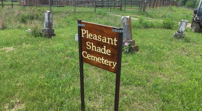
| Pleasant Shade Cemetery |
Located in NW corner S3-T59N-R21W. From Linneus, go west on Hwy B about 3 miles to Hwy Y, then north on Hwy Y about 6 miles. Turn left (west) on a gravel road; cemetery is on the south edge of the road 30 yards from the blacktop. |
| Pleasant View Cemetery |
Located in SE 1/4 S2-T58N-R19W. From St. Catharine, go east on Hwy 11 until the highway turns north; then continue north about 4 1/2 miles until the highway curves right to the east. At this point, a gravel road continues north; take this gravel road. The cemetery is about 300 yards down the road on the left (west) side. |
| Prather Cemetery* |
Located in SE corner S12-T60N-R21W. Go west from Browning on Hwy MM from Hwy 5 about 1 mile; turn south on gravel road. Continue south about 1/2 mile, then west about 0.6 mile to cemetery. Cemetery on north side of road clearly marked by archway gate. |
| Price Cemetery* |
Located in NW 1/4 S15-T60N-R18W. From intersection of Hwy 129 and Hwy HH, south of Winigan, go south on Hwy HH about 1/4 mile; cemetery will be on left (east) side of road. |
| Pulliam Cemetery* |
Also known as Gash Cemetery
Located in SW 1/4 S26-T59N-R19W. From intersection of Hwy 11 and Hwy C, north of Brookfield, go south on Hwy 11 2 1/2 miles then turn right (west) on a gravel road. Go west 1/2 mile then turn south at the intersection. Go south 1/4 mile to farm home. Drive thru farm yard (with permission) and follow dirt lane. Stay left at intersection and pass a small pond and tin barn; continue on dirt lane about 1/4 mile to a fence line. Cemetery is on the right (west) side of lane and south of the fence. |
| Purdin Cemetery* |
Located in Northeast corner, S7-T59N-R10W. Cemetery is about 1/8 mile west of Hwy 5, at the north edge of Purdin; easily visible from highway. |
| Putman Cemetery |
Located in NW 1/4 S10-T60N-R19W. From intersection of Hwy O and Hwy OO at North Salem, go west on Hwy O about 1 1/4 miles to top of first ridge west of West Yellow Creek. Park in private drive south of highway and walk south past barn and pens then veer to southwest, passing a pond on the east, to fence line. Cemetery is 300 yards south of highway marked by several small trees. |
| Ray Cemetery |
Located in NW 1/4 S23-T59N-R18W. From New Boston, go south on Hwy 129 about 2 miles to the 2nd gravel road west. Go west past a home; cemetery is on a ridge in a patch of timber about 1/2 mile southwest of the house (1/4 mile south of the gravel road). |
| Ridings Cemetery |
Located in SE 1/4 S33-T58N-R20W. From the intersection of Hwy 36 and Hwy FF (west of Brookfield), go north on Hwy FF across railroad tracks about 1 mile to second gravel road on the left. Turn left on gravel road and go about 1/2 mile; cemetery is about 1500 feet north of the road and just west of n-s fence line. |
| Rose Hill Cemetery |
Located in SE 1/4 S7-T57N-R19W. From intersection of Hwy 11 and Hwy 36 in Brookfield, go south on Hwy 11 to eastbound outer road; turn left (east) and follow outer road to cemetery. |
| Roselawn Cemetery – see Mt. Olivet Cemetery |
|
| Saint Bonaventure Cemetery* |
Located in NW 1/4 S31-T57N-R18W. From intersection of Hwy JJ (Lake Street) and Kansas Avenue in Marceline, go west about 1/4 mile past city limit; cemetery is on the left (south) side of road adjacent to a gravel road going south. |
| Saint Michael´s Cemetery |
Located in SE 1/4 S7-T57N-R19W. From intersection of Hwy 11 and Hwy 36 in Brookfield, go south on Hwy 11 to eastbound outer road; turn left (east) and follow outer road past Rose Hill Cemetery, then south to cemetery on right (west) side of road. |
| Sensentaffer Cemetery |
Located in SE 1/4 S9-T57N-R20W. From intersection of Hwy 36 and Hwy 5 at Laclede, go south on Hwy 139 for 1 mile then turn left (east) on a gravel road. Go east about 1 3/4 mile; cemetery is 400 yards north of road. A private drive going to a farm house in the area will lead to the cemetery. |
| Sights Cemetery |
Located in NW 1/4 S5-T57N-R18W. This cemetery is shown on the Linn County Road Map published by the State of Missouri, but is reported to have been destroyed by bulldozing; no trace of the cemetery or stones has been found. |
| Smith Cemetery* |
Located in SW 1/4 S23-T60N-R22W. From Meadville, go north on Hwy 139 about 13 miles to Hwy DD; then go north on Hwy DD about 1 mile to a gravel road going west. Go west on gravel road about 1/3 miles; cemetery is 1/4 mile north of the road. Best to continue west a short way and go thru a barnyard then angle northeast to cemetery. |
| Snyder/Bigger Cemetery* |
Located in SE 1/4 S30-T58N-R20W. From Laclede, go north on Hwy 5 about 1 mile then turn left (west) on a gravel road. Go west about 3/8 mile; cemetery is about 100 yards north of the road (north and east of a shop building). |
| Southerland Cemetery* |
|
| South Swedish Cemetery |
Also known as Mission Covenant Church.
Located in NW 1/4 S1-T58N-R18W. From Bucklin, go north on Hwy 129 about 5 1/2 miles, about 1 mile past a power substation on the right (east) side of road. Go go second gravel road to the west past the substation. Go west on this gravel road 1/4 mile, then turn north and go about 0.6 miles; church and cemetery are on top of the ridge on the east side of the road. |
| Sportsman Cemetery |
Located in NE 1/4 S12-T57N-R19W. From the intersection of Hwy 36 and Hwy 5 north of Marceline, go west on Hwy 36 for 2 miles; then turn north on a gravel road. Go north about 3/4 mile to a barn and concrete silage pit. Follow the fence between the barn and silage pit about 250 yards to cemetery (about 50 yards past end of fence). |
| Stains Cemetery* |
Located in SW 1/4 S27-T57N-R19W. From Marceline, go west on Hwy JJ to 90 degree left turn about 1 1/2 miles past city limit. Continue west on a gravel road about 1 1/2 miles to a low water bridge over Yellow Creek. Continue past bridge until road turns left. From here, the cemetery is about 400 yards northeast of road in a clump of trees. |
| Stein Burying Ground |
Located in S36-T57N-R18W. From Marceline, go south on Hwy 5 to city limit, then east on a gravel road about 3 3/4 miles to another gravel road going north. Go north on this road about 1/4 mile, then turn east. Continue east until this road turns north, but continue east here. Cemetery is about 300-350 yards east of the gravel road. |
| Strawberry West Cemetery |
Located in NE 1/4 S31-T59N-R21W. From intersection of Hwy 139 and Hwy B north of Meadville, go east on Hwy B 1 mile to a gravel road going north. Go north on the gravel road about 3/4 mile; cemetery is about 25 yards west of the road. |
| Stufflebean-Baker Cemetery |
Located in SE 1/4 S19-T60N-R18W. From intersection of Hwy 11 and Hwy PP, go north on Hwy PP about 2 1/2 miles, then go west on a gravel road about 1/2 mile, then turn north. Go north about 0.6 mile; cemetery is west of road on a ridge a few yards from road. |
| Swetnam Cemetery |
Located in SW 1/4 S16-T59N-R18W. This cemetery was supposed to be just south of the road and stones in the fenceline. Stones or plot could not be found; a report was that the stones had been removed to Wyandotte Cemetery. |
| Swinford Cemetery |
Located in NE 1/4 S2-T59N-R20W. From intersection of Hwy M and Hwy P north of Brookfield, go west then north on Hwy P about 4 miles to the curve where the highway turns west; the cemetery site is 50 yards west of the road. The cemetery has been destroyed. |
| Switzer Chapel Cemetery |
Located in NW 1/4 S5-T58N-R18W. From the intersection of Hwy 36 and Hwy U, north of Marceline, go north on Hwy U about 7 miles. Here the road bends to the east; go past the bend about 3/4 mile (the road again bends east). At this second bend, a gravel drive goes north. Follow this land about 0.7 mile, going north at the split in the road; cemetery is on the left (west) side of the road about 100-150 yards north of the split. |
| Thayer Cemetery |
Located in SE 1/4 S5-T57N-R18W. From the intersection of Hwy 36 and Hwy U, north of Marceline, go north on Hwy U about 1 1/2 miles to a gravel road going east near the bottom of a hill. Park on gravel road and walk uphill south on Hwy U about 60-70 yards, then walk west up over the hill; cemetery is on west slope of the hill just 50 yards from Hwy U. |
| Thorne Cemetery |
Located in S29-T59N-R20W. From Linneus, go north on Hwy 5 about 2 miles to gravel road east. Go east on gravel road about 0.7 mile to where road turns north. Cemetery is about 150 yards east along fence line from this point. |
| United BrethernCemetery |
Also known as Pleasant Grove Methodist ChurchCemetery. Located in SW 1/4 S36-T60N-R20W. From intersection of Hwy C and Hwy KK (about 2 miles east of Purdin), go east on hwy C about 1 mile then turn left (north) on a gravel road; go north about 1 mile, then east about 1/4 mile, then north 1/4 mile, then back east. Cemetery and church are on the left (north) side of road. |
| Venable Cemetery |
Located somewhere around Eversonville in T59N-R22W |
| Ware Cemetery |
Located in NE 1/4 & SE 1/4 S28-T59N-R20W. From Linneus, go east on Hwy P from intersection of Hwy 5 about 2 1/4 miles to a gravel road going north. Go north 1 1/2 miles, then turn right (east). Go east 1/2 mile where road turns north again. Go south down a lane about 0.2 mile; cemetery is about 150 yards east with several trees in it. |
| Watkin Cemetery |
Located in SW 1/4 S24-T58N-R21W. From Linneus, go south on Hwy 5 about 2 miles to a gravel road going west. Go west about 1 mile then turn left (south) on another gravel road. Go south about 0.6 mile to a private drive on the right (west) side of the road. The drive leads to a farm house; the single tombstone is in the back yard under pine trees about 100 yards west of the road. |
| Wesley Chapel Cemetery |
Located in NW 1/4 S32-T60N-R20W. Go north from Purdin on Hwy 5 about 0.2 mile to a gravel road also going north. Stay on gravel road to left about 1.6 miles then turn right (east). Go about 1/2 mile to cemetery 150 yards south of road. |
| West Liberty Cemetery |
Located in SW 1/4 S25-T59N-R21W. From Linneus, go north on Hwy 5 about 1 1/2 mile to first gravel road west. Go west on gravel road about 1 1/4 mile then turn south at a ´T´ intersection. Go south about 1/2 mile; cemetery is 250 yards west of the road just north of the line fence. |
| Worley Cemetery* |
Located in SE corner S2-T60N-R18W. From intersection of Hwy 11 and Hwy 129, go north on Hwy 11 about 1 mile to intersection with a gravel road on the left. Turn left and go about 75 yards to another ´T´ intersection; turn left and go another 75 yards; cemetery is on the left in a wooded area. |
| Wright Cemetery |
Located in SE 1/4 S21-T57N-R18W. From intersection of Hwy WW and Hwy ZZ east of Marceline, go north on a gravel road 1 mile, then turn left (west). Go west about 3/4 mile – the road dead-ends at a reservoir. Follow the old reservoir road on foot north about 750 yards; cemetery is east of old road. |
| Wyandotte Cemetery |
Located in NE 1/4 S29-T58N-R18W and NW 1/4 S28-T58N-R18W. From the intersection of Hwy 36 and Hwy U, north of Marceline, go north on Hwy U about 4 miles to a gravel road going east. Go east about 1/2 mile; cemetery is on the north side of the road surrounding the Wyandotte Church. |
| Wyant Cemetery* |
Located in SW 1/4 S20-T59N-R18W. From St. Catharine, go north on Hwy 11 about 6 1/4 miles to a gravel road going east (1st road north of ´S´ in highway). Go east about 1 1/2 miles, then turn north on a gravel road about 1/2 mile, then east 1/2 mile, then north again 0.6 to 0.7 mile; cemetery is on a ridge 75-100 yards east of the road in a pasture. |
| Yount Cemetery |
Located in Se 1/4 S21-T58N-R20W. From the intersection of Hwy 36 and Hwy FF (west of Brookfield), go north on Hwy FF about 3 1/4 miles to a gravel road going west. Go west for about 0.6 mile; cemetery is on the right (north) side of the road. |